The Sustainable Trails Program is in now in its second full season of comprehensive data inventory and analysis on the 14ers. Data on 23 routes, totaling 98 miles has been collected and analyzed with 19 routes scheduled to be inventoried in 2013. CFI uses this data to prioritize trail work and restorative efforts on each peak.
To date, the Sustainable Trails Program has assessed the condition of 8,359 existing features. Check steps, crib steps, mono & retaining walls, and drains are several examples of existing features that exist on our 14ers trails. Some existing features, such as drains require routine maintenance, while others require repair, such as a failing step that’s been subject to heavy foot traffic and inclement freeze/thaw cycles. Of the 23 routes inventoried, 21 percent of the existing features require some type of action. That means 79 percent of existing features require no action. That’s pretty good considering many of the inventoried features were installed as long as 18 years ago.
The installation of 7,382 features has been proposed, and 3,213,006 cubic feet of erosion totaling 665 individual issues (trail erosion, braiding widening) has been cataloged. The detail in which all this is documented is standardized and thorough. For example for each feature and issue the distance to the material that will be used for repair or new construction is documented along with height, length, width, depth, ascertained condition, recommended action and a picture.
Say I want to log the location and condition of a set of crib steps. I “create” a feature and populate the drop down menus with the appropriate information. While I’m entering this data, the GPS unit is collecting a position (location) a second. It usually takes around 25 positions (seconds) to record a single feature, or in this case a set of crib steps. I did a quick calculation to figure out how much time I spend standing in one spot “collecting” hits and filling in drop down menus. On the 23 routes inventoried to date, I’ve spent about 134 hours standing still in multiple spots, all over the length of several trails of course.
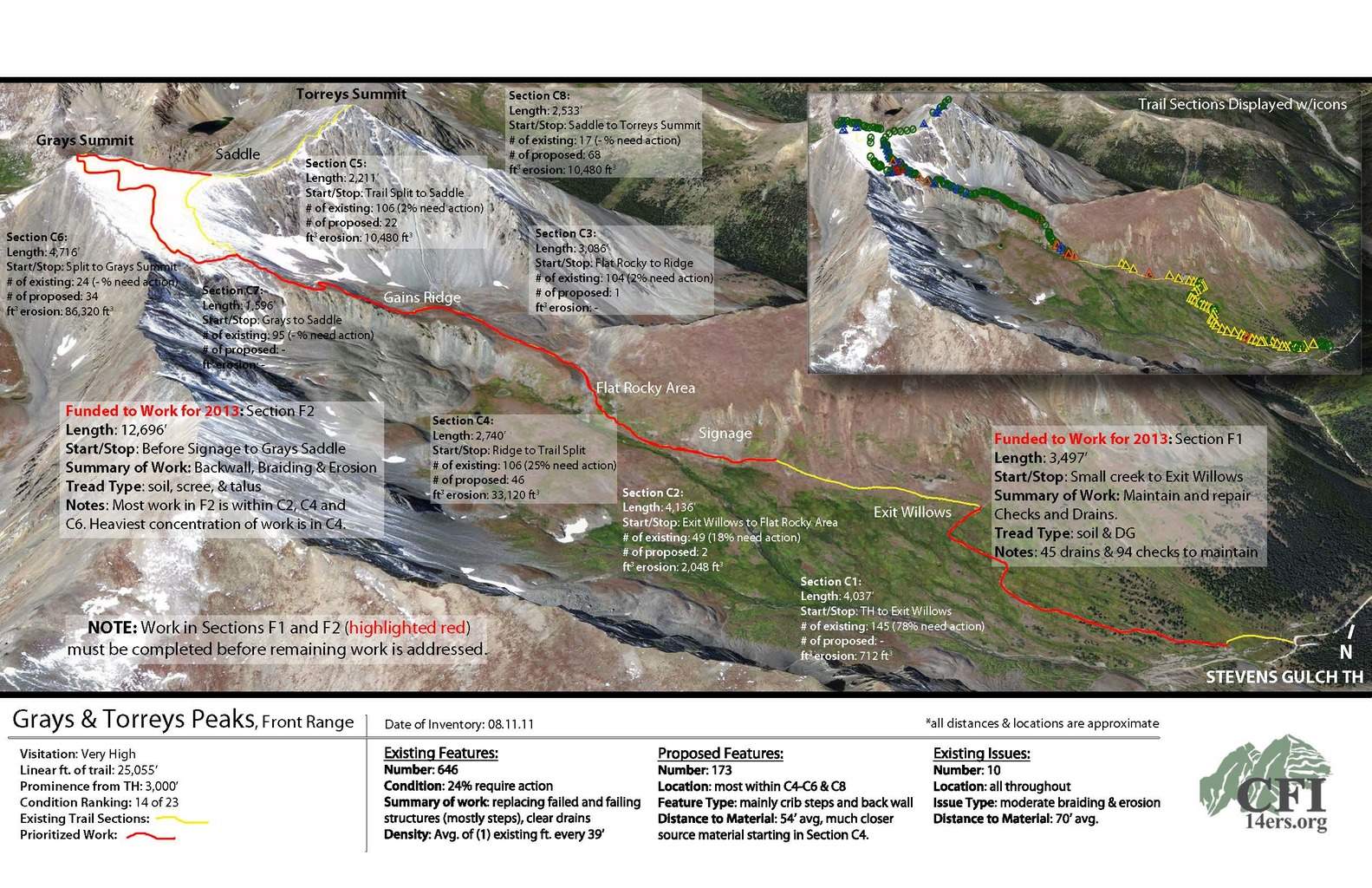
What I’ve been working on most recently are what we’ve been referring to as peak planning documents – used by our Adopt and Roving Crews as a quick reference files prioritizing trail work on each peak they work on (see Grays & Torreys example above). With a quick look at one of these 11×17 reports, our crews can quickly identify where on the trail CFI is funded to work this season, how many cubic feet of erosion or trail braiding exist in that section, how many existing features there are and the percentage that require some action (and the type of action), as well as the number and type of proposed features.
I’m looking forward another great season of data collection. If you’re on the peaks this season and notice someone moving up the trail very slowly, staring at the ground, or taking pictures of rocks, say hi, because it’s probably me.