Colorado 14ers Statewide Report Card
SECONDARY INVENTORIES 2017 – 2019
Between 2017 – 2019, Colorado Fourteeners Initiative completed baseline trail condition inventories for 15 routes that were not included in the first phase. In addition, CFI performed secondary invenvtories on 14 routes that were originally evaluated in 2011 – 2013. These secondary assessments note how on-the-ground trail conditions have changed and track cash and volunteer investments in the intervening years.
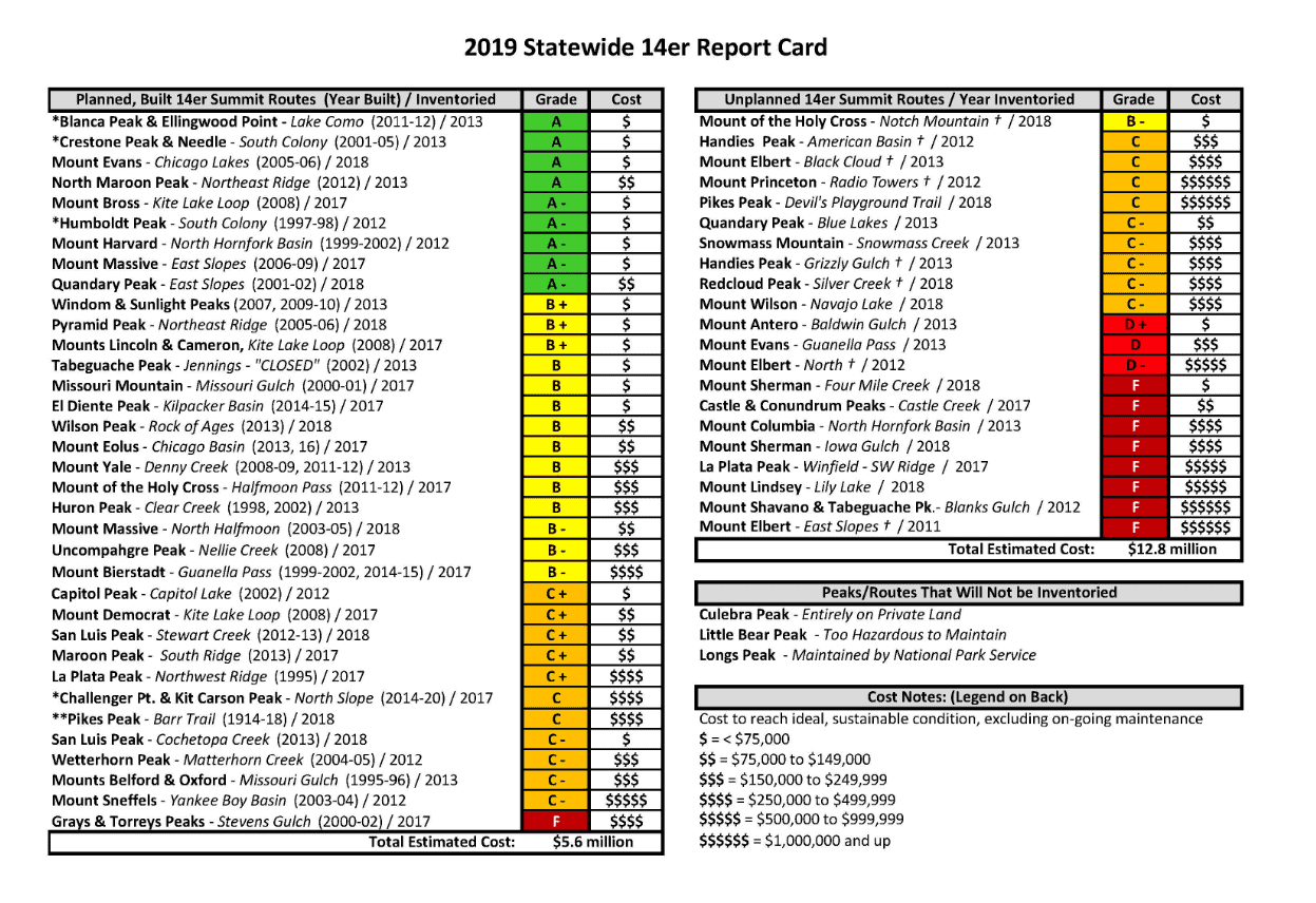
The result was an updated “Statewide 14er Report Card” which outlines $12.8 million in needed new summit trail construction projects and a further $5.6 million in major improvements to existing trails. CFI’s Sustainable Trails analysis now covers 56 14ers routes, including all standard and some secondary routes on the Forest Service and BLM-managed peaks.
Download the 2019 14er Report Card — PDF
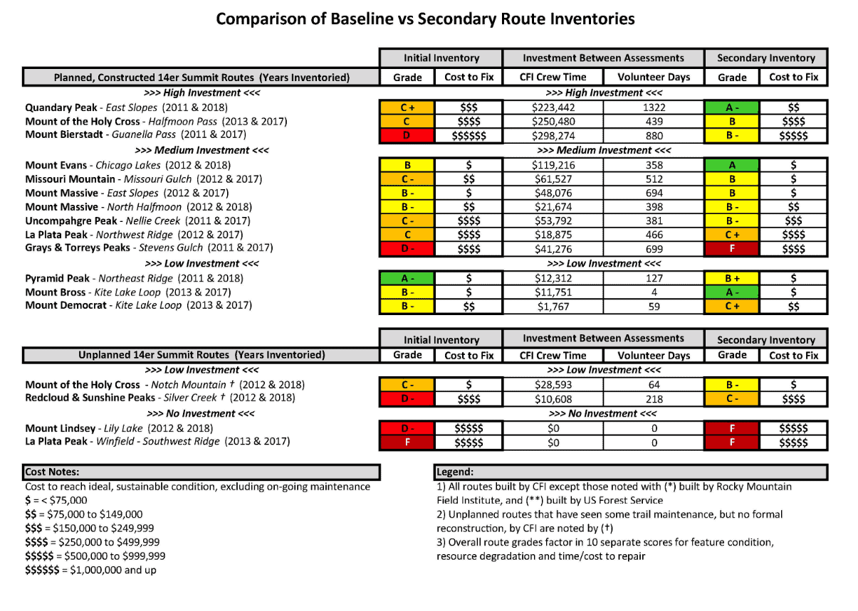
The updated report also compares 17 routes, both planned and unplanned, to reveal how trail conditions changed over time with vary levels of investment. Data provided for each route on the chart includes:
- The initial “letter grade” assigned to that route and the estimated cost to bring that trail to a more sustainable condition
- Cash raised and expended by CFI for paid seasonal trail crews and the number of volunteer days recorded
- The secondary “letter grade” and an updated estimate of the cost to fix/maintain each route
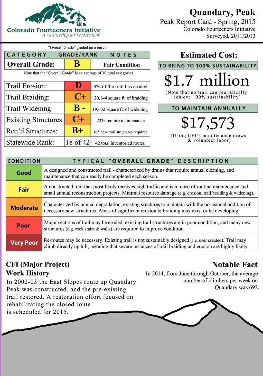
For example, CFI reports that the trail conditions on Quandary Peak improved from a C+ in 2011 to an A- in 2018. Since 2011, CFI invested more than $220,000 in paid staff labor and an additional 1,322 days of volunteer labor to help protect this fragile, yet extremely popular mountain.
 BASELINE INVENTORIES 2011 – 2013
Colorado Fourteeners Initiative began inventorying 14er summit trails in 2011 to help answer a few related questions about the long-term sustainability of Colorado’s 14er summit trail network:
- What are the conditions of the planned 14er summit and approach trails built since CFI’s inception in 1994 that reflect an investment of many millions of dollars, as well as those of the many unplanned 14er trails that hikers have literally trampled into the high-altitude tundra?
- How are the conditions of both planned and unplanned trails changing as more people climb the 14ers each year and the forces of nature continue to erode these built features?
- What are the highest priorities for building out the 14er summit trail network by constructing new, planned summit routes and reconstructing existing trails that are not fully hardened?
Over three field seasons, Ben Hanus, now CFI’s Field Programs Manager, hiked 42 summit trails while conducting detailed, foot-by-foot, GPS-based baseline inventories noting the condition of existing constructed trail features, the extent of natural resource problems, and the complexity of performing needed trail improvements. The result is a GIS database containing more than 20,350 data points regarding 10 different factors, from on-the-ground issues such as the extent of erosion and trail widening, to the amount and accessibility of natural rock source needed to improve these wilderness trails.
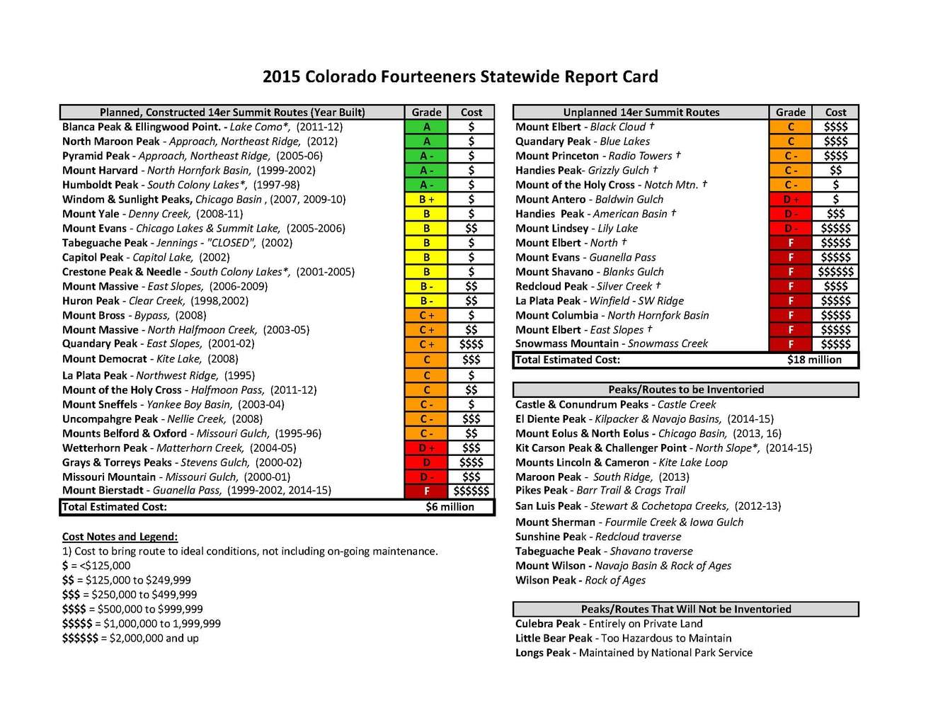
The result is CFI’s first Colorado 14ers Report Card, which ranks the condition of 42 existing 14er trails — both planned and unplanned. Together, CFI has estimated that bringing all of these trails up to ideal, long-term sustainable conditions will cost at least $24 million — $6 million to improve 26 Forest Service-planned routes and $18 million to build 16 new planned trails where only user-created routes exist today. A further 16 routes remain to be inventoried. Some trails travel several miles from trailhead to summit, while others are short approach trails that end at the start of more technical climbing. Since each route covers unique high-alpine terrain with different rock, soil, and vegetation types, they offer unique challenges. Download the full Colorado 14ers Statewide Report Card and Press Release.
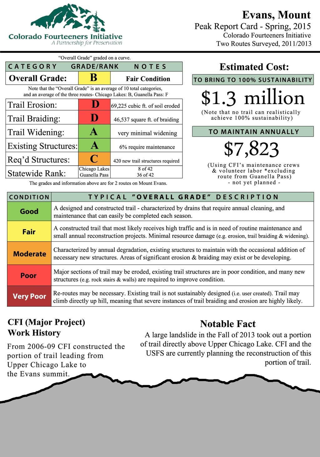
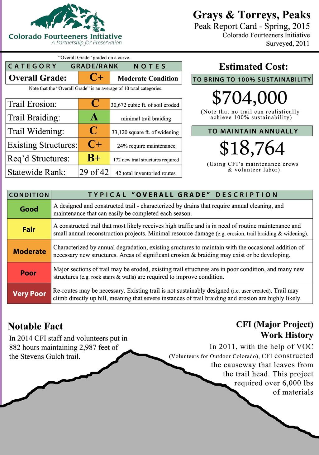
Front Range: The five Front Range 14ers closest to Denver (Mounts Bierstadt and Evans, and Grays, Torreys, and Quandary Peaks), which together see about 100,000 annual hiker use days, are projected to take more than $6.3 million to bring to long-term sustainable conditions. Peak-specific report cards show the relative conditions of these trails, as well as the costs to fully harden the trails.
- Front Range 14ers Overview
- Mount Bierstadt (Guanella Pass route)
- Mount Evans (Chicago Lakes and Guanella Pass routes)
- Grays and Torreys Peaks (Stevens Gulch route)
- Quandary Peak (East Slopes and Blue Lakes routes)
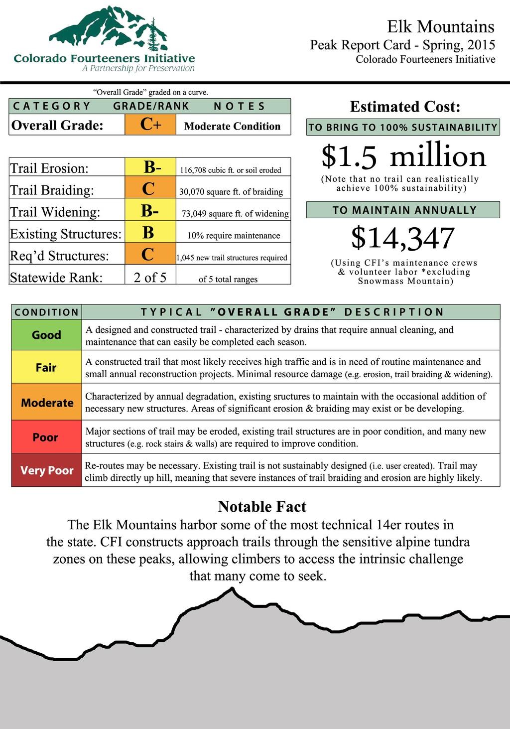
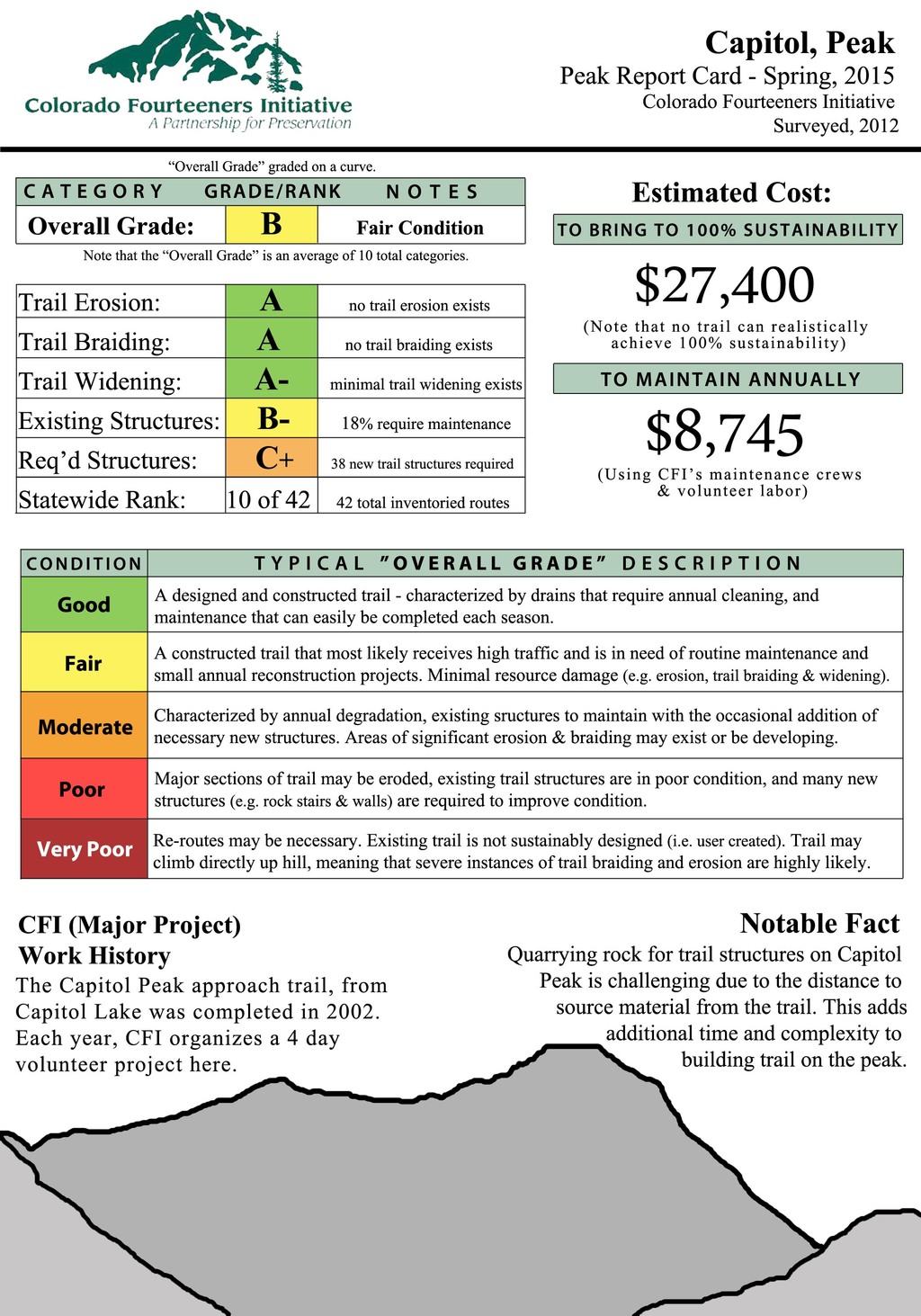
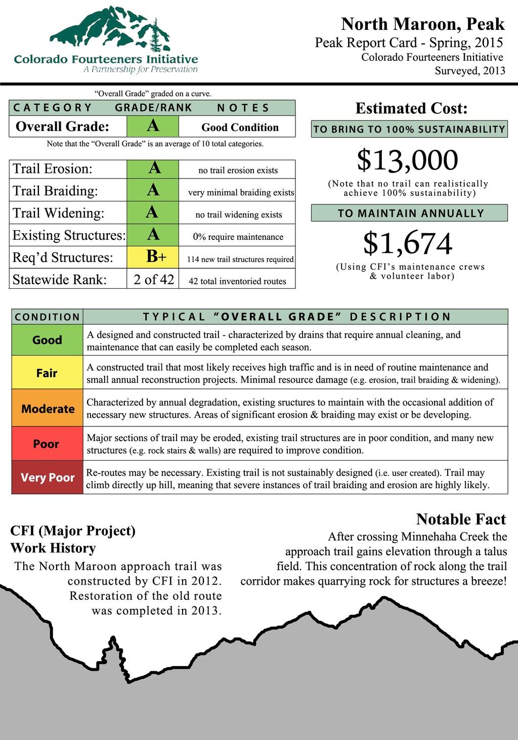
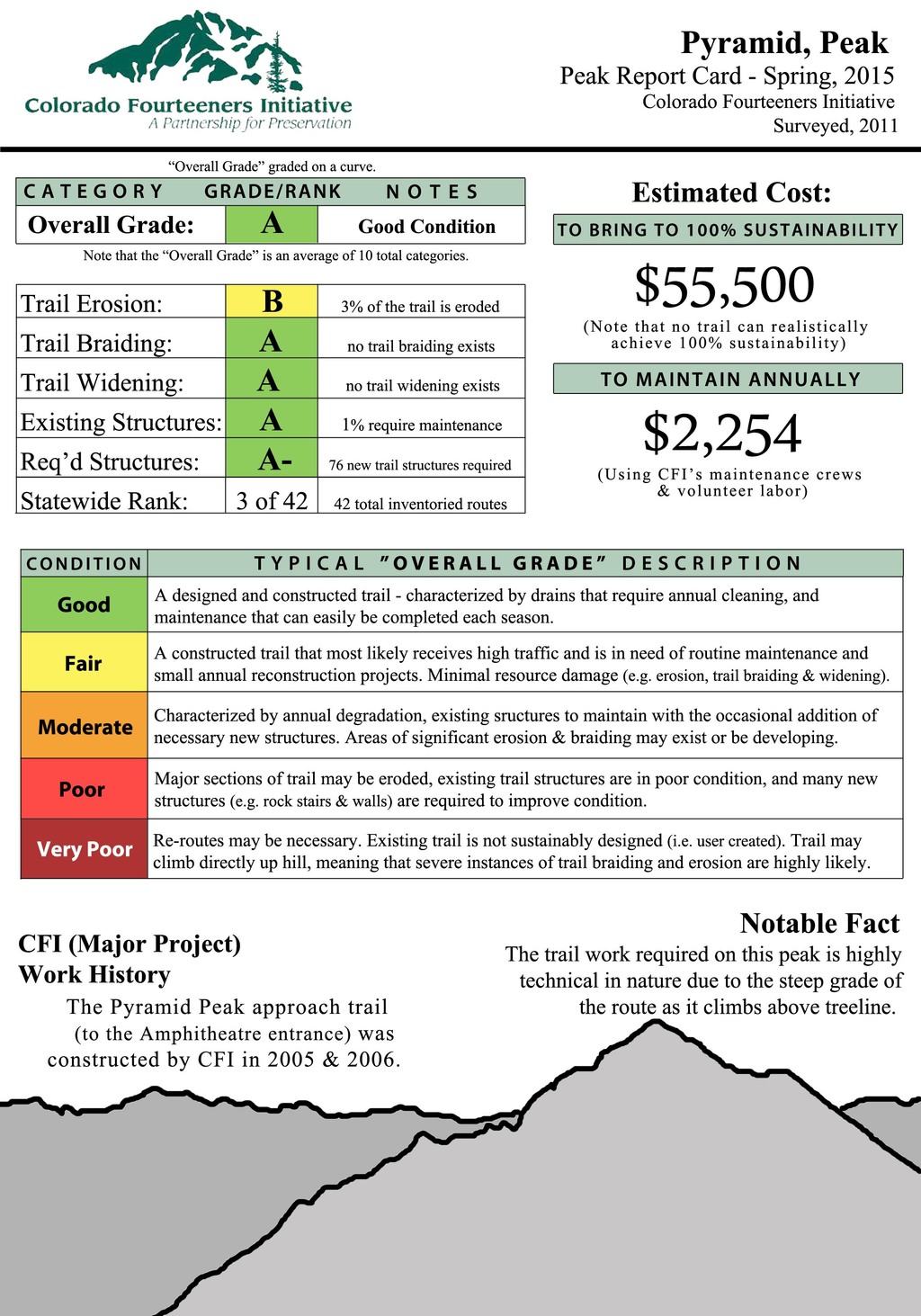
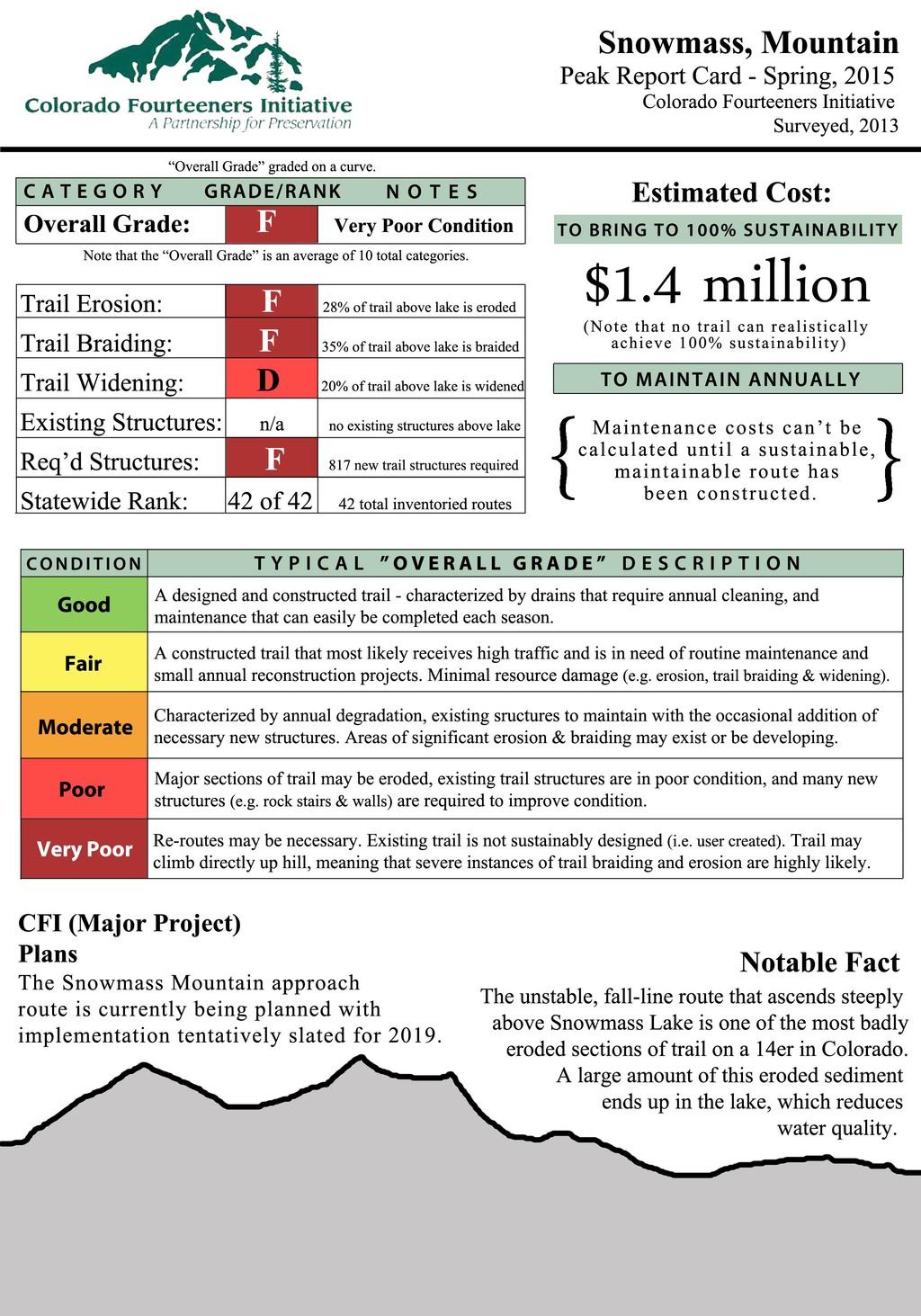
Elk Mountains: The Elk Mountains near Aspen contain some of Colorado’s most challenging 14er routes. The CFI-built trails tend to be short and among the highest-rated in the state since they only serve as approach routes that transport climbers through fragile alpine tundra zones to the harder scrambling on rock above. The estimate to bring inventoried routes up to ideal conditions is $1.5 million, almost all of which involves reconstructing the route on Snowmass Mountain (F grade), which CFI plans to begin in 2019.
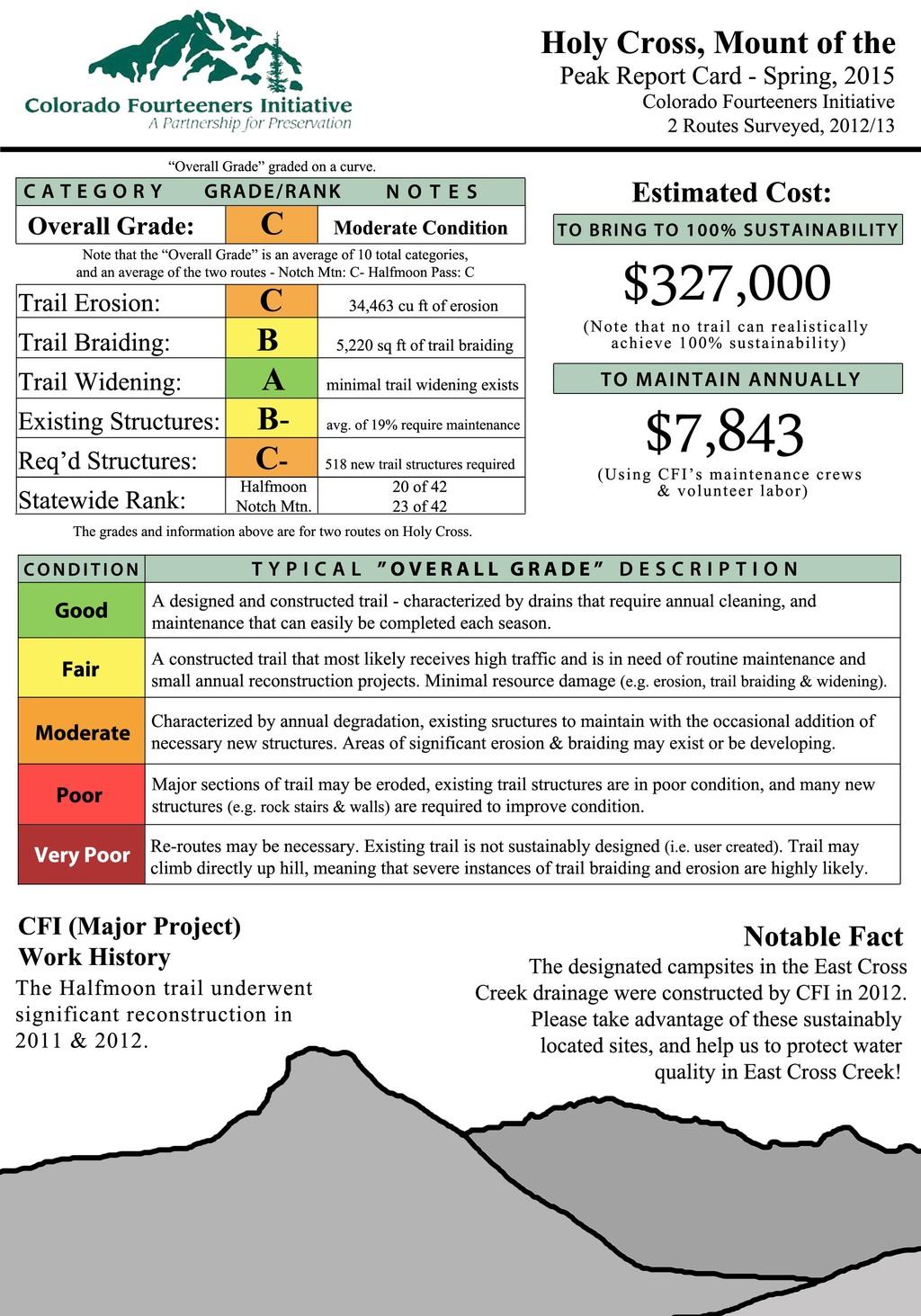
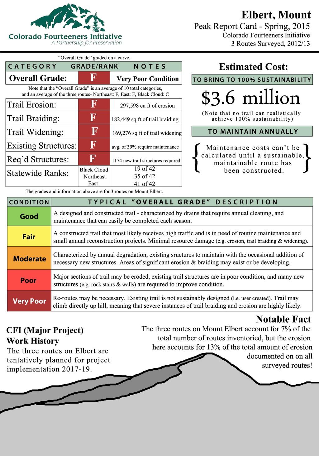
Sawatch and Mosquito Ranges: These 14ers are close enough to climb in a day from the Denver metro area, but do not receive quite as much use as the Front Range peaks. Nevertheless, trail impacts can be quite severe on specific routes. Here are grades for a few representative peaks. Significant resources have been devoted to Mount of the Holy Cross in recent years, while Mount Elbert’s three routes –including two that are graded F– need $3.6 million to repair, make this the most expensive 14er in the state.
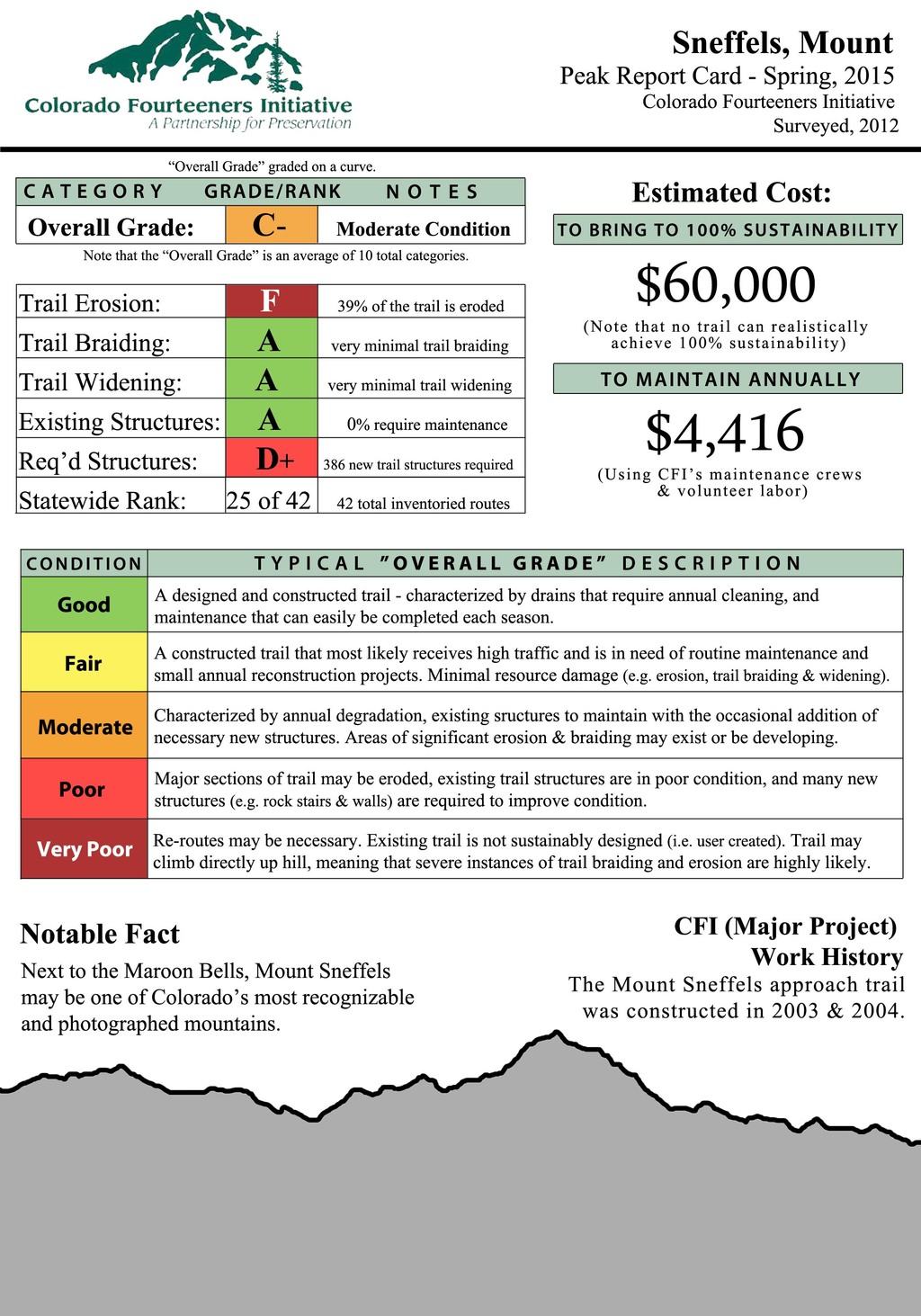
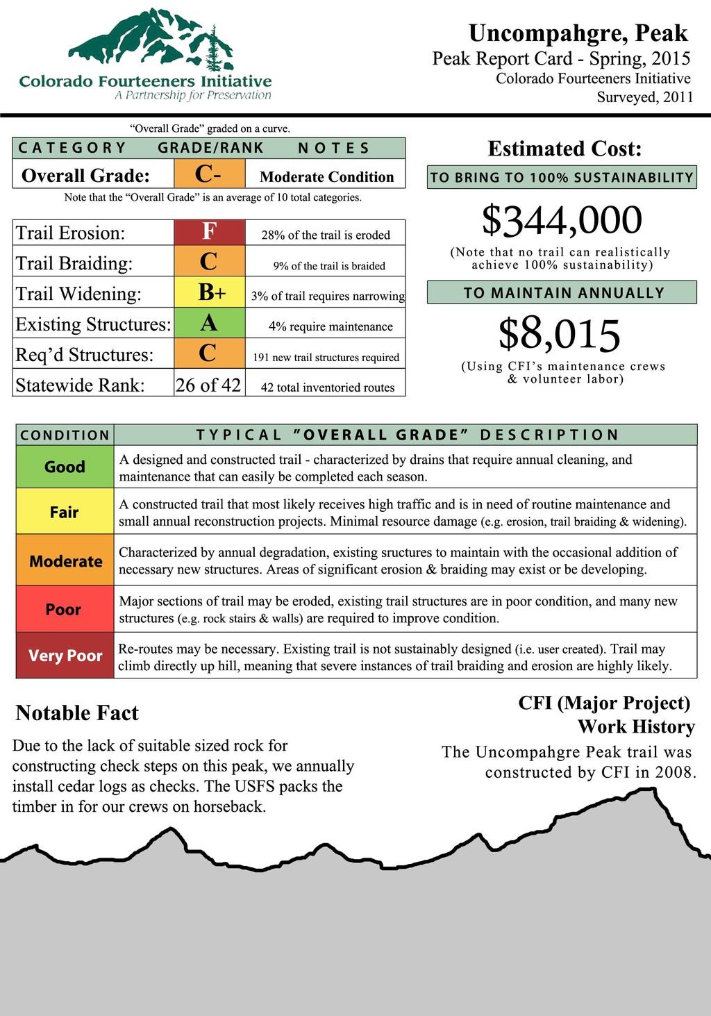
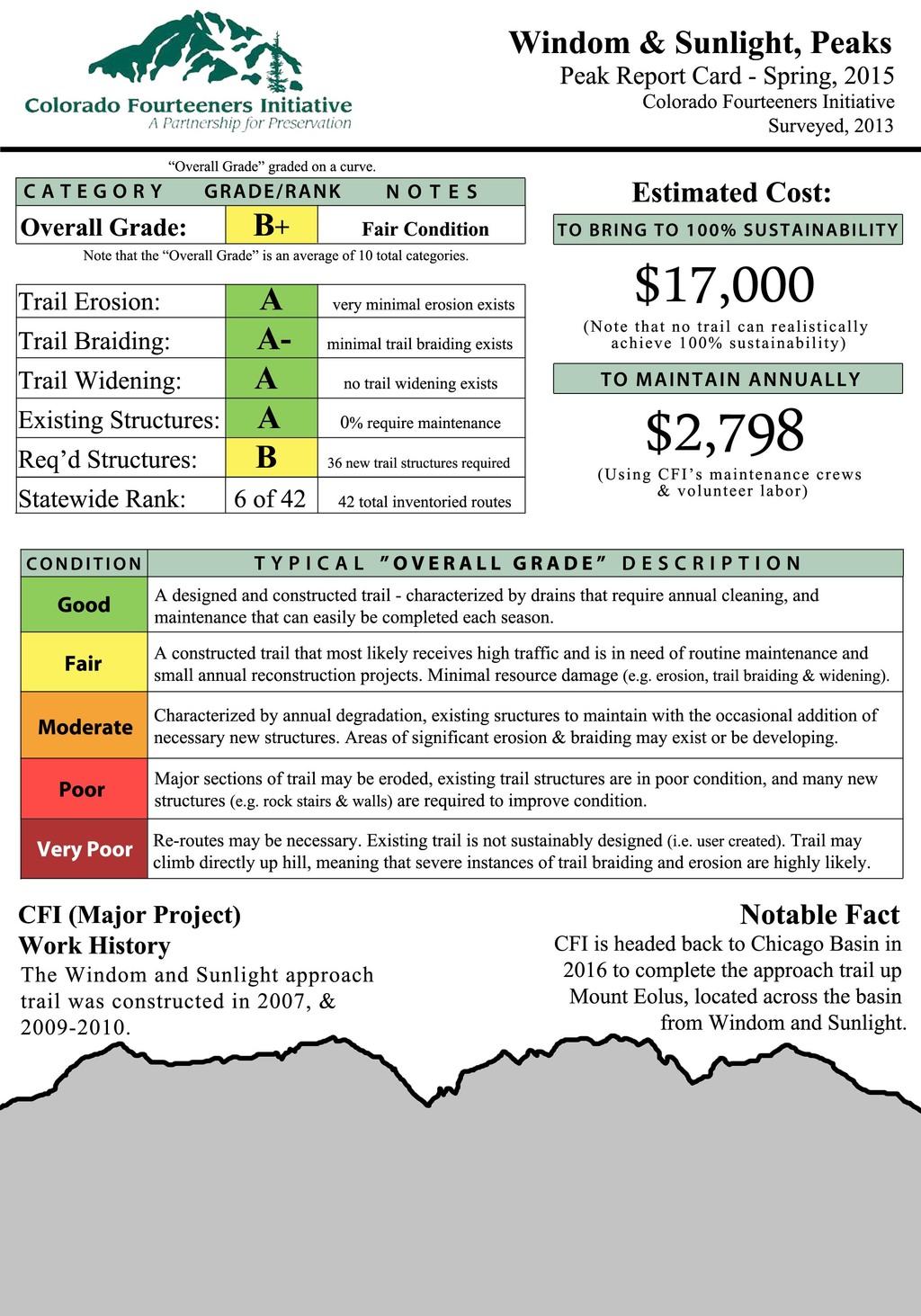
San Juan Mountains: The 13 peaks of the San Juan Mountains are the most distant 14ers, receive the lightest amount of hiker traffic, yet are in the worst condition of the five major ranges with an average grade of D+. The trails in Chicago Basin are among the better maintained in the state, but higher-use 14ers such as Uncompahgre and Sneffels have significant work remaining. Here are a few peak-specific report cards:
Because the baseline trail condition inventories were collected using GPS-based information, CFI is able to show the trail conditions in more lifelike ways using Google Earth flyover videos. Here are examples that show the range of conditions on three disparate peaks:
- Capitol Peak: The short 14er-specific trail from Capitol Lake to the Capitol-Daly saddle is short and in fair condition (B) due to a sustainably designed route that has seen frequent attention and receives little hiking use. Bringing this trail up to long-term sustainable condition is estimated to cost under $125,000. Watch the Capitol Peak Google Earth flyover video.
- Mount Lindsey: This longer trail was never planned and, as a result, is overly steep and heavily eroded. Despite receiving modest hiking use, it is in poor condition (D-) and in need of a full reconstruction. Bringing this trail up to long-term sustainable condition is estimated to cost between $1 million and $2 million. Watch the Mount Lindsey Google Earth flyover video.
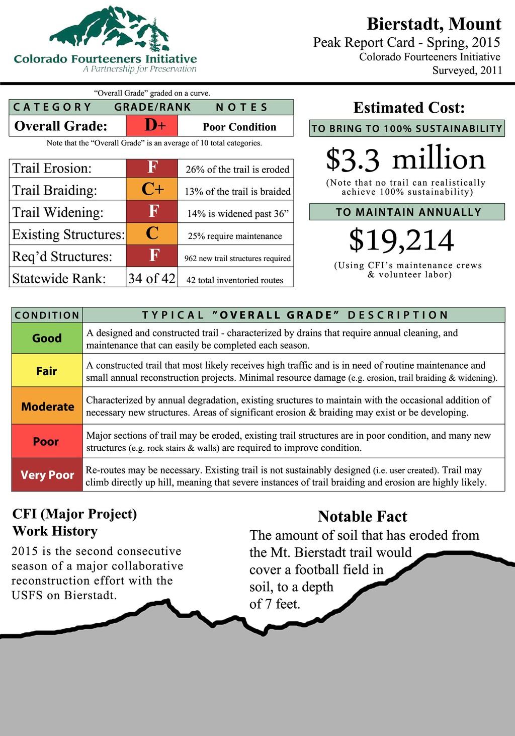
- Mount Bierstadt: The Bierstadt summit trail is in very poor condition (F) due to the confluence of several problems: exceptionally high use (estimated at 35,000-40,000 hiker use days annually — the highest in the state), the fact that almost the entire trail covers vegetated slopes and is prone to becoming wet and muddy, and the almost total lack of native rock source with which to harden the trail. Despite a projected six seasons of major trail reconstruction work, CFI estimates that a further $3.3 million is required to sufficiently build out this trail. Watch the Mount Bierstadt Google Earth flyover video.
Additional peak-specific report cards for inventoried routes in the Elk Mountains, Sawatch Range, San Juan Mountains, and Sangre de Cristo Range will be posted over the coming week. CFI plans to continue assessing the changing conditions and amount of hiking use on the 14er summit and approach trails through the Sustainable Trails program. Look for new and updated information soon.