Interestingly, before I knew where I was going to work this summer, I had never heard of Mount Evans. I quickly found out it is one of the two 14ers with a paved road leading to the summit (along with Pikes Peak). Even later, I found out it is the highest paved road in North
America. How special!
Wait, this place is a Wilderness area? Something doesn’t quite add up, and I know for sure that Edward Abbey wouldn’t approve: “ No more cars in national parks. Let the people walk. Or ride horses, bicycles, mules, wild pigs–anything–but keep the automobiles and the motorcycles and all their motorized relatives out.” said the old curmudgeon in Desert Solitaire. Coming from, and having enjoyed wilderness areas in Montana, I know that Abbey’s rant about motorized vehicles made practical sense in the wilderness areas of that state. But Abbey was ranting about National Parks , not Wilderness Areas, which, by legal definition, ought to be road less (per the
Wilderness Act of 1964). National Parks are allowed to set their own rules regarding roads and access, unlike wilderness areas. So, why is there a road in the Mount Evans Wilderness?
Before getting to the anticlimactic answer to that question, I’d like to ask, why is it called Evans? It’s safe to say Evans is likely named after a person who is most likely male, white, and deceased. Originally, the famous Prussian painter and first ascender of Evans Albert Bierstadt gave the peak its first unofficial name, Mount Rosalie, after another man’s wife who eventually became his, in the 1860s.
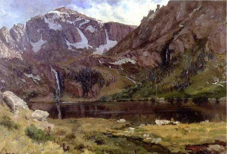
Mountain Lake, Albert Bierstadt, ca 1863, showing upper Chicago lake and Spalding
30 years later in 1895, however, the Colorado Legislature voted to rename the peak after John Evans, the second governor of the Colorado Territory who resigned in disgrace following his involvement in one of the worst Native American Massacres in U.S. history, the Sand Creek Massacre. Despite that ugly truth, Mount Evans is still the name of the one 14er towering over the mile high city.
Later, in the early 1900s, Denver found itself competing with mountain recreation around Colorado Springs and the Pikes Peak area. So, the City and County of Denver established the Denver Mountain Parks System. During this time, the state gave the City and County of Denver approval to buy land well outside its municipal boundaries (Evans is in Clear Creek County), explaining why you see
Denver signage and rangers collecting their fees at Summit Lake, the lake forming the cirque below the Mount Evans Massif. Up to 1918, Denver had gained control of parcels of land from above Evergreen and started construction of the lower phases of what is now the Mount Evans Scenic Byway. Seeing dollar signs in their eyes following this initial road construction, Colorado Territory and Denver officials sought to then turn Mount Evans into a National Park, but the area around Mount Evans was already under the management of the Forest Service. The ensuing disagreements between the City/County of Denver, U.S. Congress, and The Forest Service eventually sparked the creation of The Bureau of Public Roads (now the Federal Highway Administration, a major funder of CFI’s Mount Evans project this summer), and the area remained under Forest Service management.
The segment of the road between Echo Lake and the Summit (the segment containing all the alpine zone) was completed between 1923 and 1930 with great cost to human and animal life. Disease among workers and even horse suicide were common, and the high altitude caused the steam shovels to operate at 50% efficiency. The road today, though, is obviously a product of continuous and annual maintenance. The effects of winter and freeze/thaw cycles, as well as excavation from critters like Marmots, would probably reduce the pavement to undriveable rubble in the matter of a couple decades. At 50 feet below the summit sits the remains of the Mount Evans Crest House, which was a restaurant and hotel that was built in 1941 and destroyed by a propane canister fire in 1979. The remains still stand today and serve as a shelter for tourists and a reminder of the limitations and hubris of human ambition against the powerful natural forces created by a 14er.
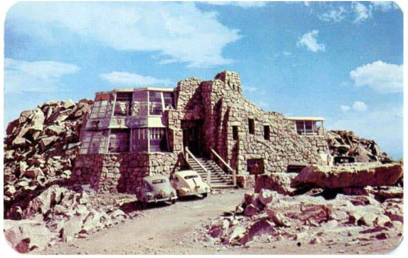
Mount Evans Crest House, ca 1950
So why is there still a road in a designated wilderness area? Well quite simply, the laws enforcing roadless and non motorized zones began in the 1950s and culminated into the Wilderness Act of 1964, well after completion of the first iteration of the road. The road was effectively “grandfathered in” and the Wilderness Boundary was conveniently drawn around the corridor of the road. So, in my opinion Mount Evans looks and feels more like a National Park, yet is still technically a wilderness area. Would Ed Abbey still be pissed despite this technicality? Probably, yes.